ricer68
Pro
- Joined
- Mar 23, 2016
- Messages
- 133
- Age
- 39
- Location
- Wabash Indiana
- Country
- USA
- Snowmobile
- 2007 Yamaha Apex GT
- LOCATION
- North East Indiana
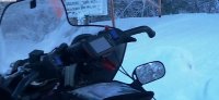
Spent some time in the shop this evening making a mounting bracket for my Garmin. Not looking to bad for my first attempt. Cant wait to get it finished and mounted.


ricer68
Pro
- Joined
- Mar 23, 2016
- Messages
- 133
- Age
- 39
- Location
- Wabash Indiana
- Country
- USA
- Snowmobile
- 2007 Yamaha Apex GT
- LOCATION
- North East Indiana
Got it finished up this morning. I'm pretty happy with it.


Doc Harley
TY 4 Stroke God
- Joined
- Oct 17, 2016
- Messages
- 3,408
- Age
- 55
- Location
- Here & there
- Country
- USA
- Snowmobile
- '17 Sidewinder LTX SE
I'm going to make something this week. Nice to get ideas. Although not alot of options. As far as where.
ricer68
Pro
- Joined
- Mar 23, 2016
- Messages
- 133
- Age
- 39
- Location
- Wabash Indiana
- Country
- USA
- Snowmobile
- 2007 Yamaha Apex GT
- LOCATION
- North East Indiana
Yeah I wanted to do this for the last year, decided to just start tearing it apart and figure out how to make one work. Not a lot of room between the windshield and the dash.I'm going to make something this week. Nice to get ideas. Although not alot of options. As far as where.

DGZRT
VIP Member
- Joined
- Feb 23, 2006
- Messages
- 1,181
- Location
- Stevens Point Wisconsin
- Country
- USA
- Snowmobile
- 2008 Vector shorty, 17 Shitdoo 1200X, 2000- pullmyass-340 for Grandkids
Great location ! Easy to see and still keep eyes on trail..
steveg_nh
TY 4 Stroke Junkie
That looks great. Nice job! I put mine on the riser.


steveg_nh
TY 4 Stroke Junkie
I wish I could do metal work like that. I could solve so many of my own issues. That is really nice work.
DGZRT
VIP Member
- Joined
- Feb 23, 2006
- Messages
- 1,181
- Location
- Stevens Point Wisconsin
- Country
- USA
- Snowmobile
- 2008 Vector shorty, 17 Shitdoo 1200X, 2000- pullmyass-340 for Grandkids


Redbeard
Lifetime Member
- Joined
- Oct 14, 2011
- Messages
- 1,659
- Location
- IN
- Country
- USA
- Snowmobile
- 2012 Apex, 136 M20, PB80
2008 Vector, 136 M20, PB80
My handlebars are already cluttered with my bush Garmin, Ride light and air pressure gauge. 
I like what Ricer did above.

I like what Ricer did above.
DGZRT
VIP Member
- Joined
- Feb 23, 2006
- Messages
- 1,181
- Location
- Stevens Point Wisconsin
- Country
- USA
- Snowmobile
- 2008 Vector shorty, 17 Shitdoo 1200X, 2000- pullmyass-340 for Grandkids
Wow your BAR'S win! LOL ! I have a 6" Garmin Nuvi 68lm. and use Red Pine Mapping and have good luck with them . They send me yearly updates ! I just punched a small hole in the back of the case and run the power cord down to the 12v socket seems to work good. I also carry a Garmin Etrex for backup in my pack. Its color screen but is very small. I'm going to try the APP, Ride Command by Polaris. From what I have read if everyone in the group has it and your all logged in you can track the other people in the group. We shall see ! Everyone have a Merry Xmas !!

Wow your BAR'S win! LOL ! I have a 6" Garmin Nuvi 68lm. and use Red Pine Mapping and have good luck with them . They send me yearly updates ! I just punched a small hole in the back of the case and run the power cord down to the 12v socket seems to work good. I also carry a Garmin Etrex for backup in my pack. Its color screen but is very small. I'm going to try the APP, Ride Command by Polaris. From what I have read if everyone in the group has it and your all logged in you can track the other people in the group. We shall see ! Everyone have a Merry Xmas !!
You are lucky to ride where there is cell phone coverage. Its a strange situation with the phones/apps/GPS/Satellite devices. Phones have GPS and will work offline with offline maps but you lose all communication so the Polaris app and anything like that won't work reliably if you aren't covered by cell phone coverage (?).. Satellite devices (Spot, Garmin/DeLoreme Inreach) give you awesome coverage and great battery life but are crap for maps due to the small screen, they will work with offline maps on your phone but none of them support routing. The problem with most if not all offline maps is that few are routable. A GPS device like the Nuvi's are great for tracking but lack battery capacity and must be hard wired for any really long ride, and they are not weatherproof, and will not take basecamp downloaded maps, etc.. plus if you take them off the sled they die in an hour in the cold. That leaves the Garmin Zumo and the larger walking GPSs (Oregon, Montana) as being a great mix of battery capacity, expandability (SD-Cards), route planning (directly on device or will take maps from Garmin Basecamp) but you end up with pretty small screens. The Garmin Montana looks like the best option overall, it has enough battery capacity for a full day+ of riding, is portable enough for a SHTF (the sled died) and I have to hike out scenario, the touchscreen is glove friendly, and it will take routable maps (Trakmap) and basecamp downloaded maps.
DGZRT
VIP Member
- Joined
- Feb 23, 2006
- Messages
- 1,181
- Location
- Stevens Point Wisconsin
- Country
- USA
- Snowmobile
- 2008 Vector shorty, 17 Shitdoo 1200X, 2000- pullmyass-340 for Grandkids
You are lucky to ride where there is cell phone coverage. Its a strange situation with the phones/apps/GPS/Satellite devices. Phones have GPS and will work offline with offline maps but you lose all communication so the Polaris app and anything like that won't work reliably if you aren't covered by cell phone coverage (?).. Satellite devices (Spot, Garmin/DeLoreme Inreach) give you awesome coverage and great battery life but are crap for maps due to the small screen, they will work with offline maps on your phone but none of them support routing. The problem with most if not all offline maps is that few are routable. A GPS device like the Nuvi's are great for tracking but lack battery capacity and must be hard wired for any really long ride, and they are not weatherproof, and will not take basecamp downloaded maps, etc.. plus if you take them off the sled they die in an hour in the cold. That leaves the Garmin Zumo and the larger walking GPSs (Oregon, Montana) as being a great mix of battery capacity, expandability (SD-Cards), route planning (directly on device or will take maps from Garmin Basecamp) but you end up with pretty small screens. The Garmin Montana looks like the best option overall, it has enough battery capacity for a full day+ of riding, is portable enough for a SHTF (the sled died) and I have to hike out scenario, the touchscreen is glove friendly, and it will take routable maps (Trakmap) and basecamp downloaded maps.
These are all valid points ! If i'm in remote areas I keep my Garmin Etrex as back up it has all the maps on a SD card you can overlay Way points , highways , gas stations, and anything else ! It will hold battery power for about 14 hours but it just sucks looking at the 2" screen. The Polaris ride command is more for me and the wife. she like to be able to track me down LOL. If your carrying a phone it never hurts to have then APP on there!
These are all valid points ! If i'm in remote areas I keep my Garmin Etrex as back up it has all the maps on a SD card you can overlay Way points , highways , gas stations, and anything else ! It will hold battery power for about 14 hours but it just sucks looking at the 2" screen. The Polaris ride command is more for me and the wife. she like to be able to track me down LOL. If your carrying a phone it never hurts to have then APP on there!
True enough although I am not sure I want the wife figuring out how fast I am going at any given time.
I was more just lamenting the state of the industry. We have helmet comms that bridge rider to rider and can provide lots of cool info, we have satellite that will keep you covered everywhere, Phones that only work where there is a signal, etc... I just wish I had one device that was more of a weatherproof GPS mapping solution that paired with my phone and had an option for satellite ... but that's just me trying to not crowd the handlebars
ricer68
Pro
- Joined
- Mar 23, 2016
- Messages
- 133
- Age
- 39
- Location
- Wabash Indiana
- Country
- USA
- Snowmobile
- 2007 Yamaha Apex GT
- LOCATION
- North East Indiana
I'm using a Garmin Nuvi 52LM. Its not weather resistant. Yeah I'm using VV mapping, got a Garmin handheld with my apex when I bought it and used the card out of it in the nuvi. And as far as John Deere goes that's the only power unit on the farm that's green.Ricer, first off...you ride Yamaha AND use John Deere equipment!
Nice work on mounting your Garmin! What model of Garmin are you using and is it weather resistant? I've been thinking of doing the same thing for a while. Are you also using the VV mapping software?
Sorry for all the questions.
!")
CaptCaper
TY 4 Stroke God
- Joined
- Jan 1, 2007
- Messages
- 2,181
- Location
- Northern N.H.
- Country
- USA
- Snowmobile
- 2016 RS Vector XTX 1.25 Lug wifes..2013 RS Vector LTX.. 2003 600 VMax Past Machines 3-2007 Attaks 1-2010 Vector LTX.. sorry no Stinkdoos or poo's cats.
That looks great. Nice job! I put mine on the riser.
View attachment 134983 View attachment 134984 View attachment 134985 View attachment 134986
Funny I did the exact same thing years ago. Run the rugged mount now as well with Montana.. thinking of putting on a Garmin 276cx but they are so so big.. I can't get used to the size. I can just see people looking at me as I pull up at intersections,etc. I wish they made a slightly smaller version.. kind of in between Montana and 276cx.
Mine is mounted a bit higher on the riser. With it so close to our face not to much need for a bigger one but a smaller verison of the 276cx would be still awesome. I had a 276c for a while on the riser on it as well
Attachments
Similar threads
-
This site uses cookies to help personalise content, tailor your experience and to keep you logged in if you register.
By continuing to use this site, you are consenting to our use of cookies.